
AccuWeather hurricane experts are closely monitoring two storms churning through the Pacific and a tropical rainstorm that formed Thursday afternoon in the Atlantic.
Lorena is forecast to bring gusty winds and heavy rainfall to parts of northwestern Mexico. Life-threatening flash flooding, road washouts and mudslides are possible in the region.
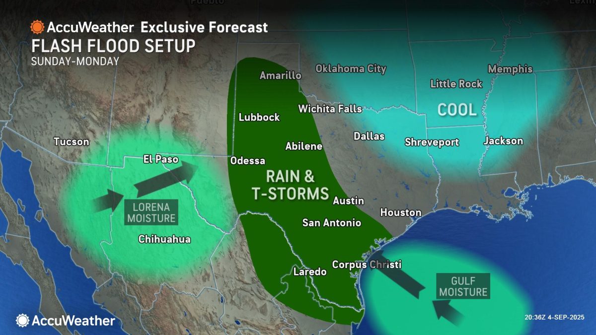
“Lorena is quickly losing wind intensity as it approaches the coast of western Mexico. Areas across western Mexico could see 4 to 8 inches of rainfall and possible flash flooding,” AccuWeather® Lead Hurricane Expert Alex DaSilva said.
The surge of tropical moisture could bring downpours, thunderstorms and flooding issues to parts of the southwest U.S.
AccuWeather® Chief Meteorologist Jonathan Porter says a slow-moving complex of thunderstorms producing persistent downpours can develop Sunday afternoon across central Texas and then move into South Texas on Sunday night into Monday.
“Residual tropical moisture from Lorena can be drawn into the complex of thunderstorms, as well as an influx of tropical moisture from the Gulf. This dangerous combination could trigger flooding issues, especially in areas with steep terrain and arid soils like the Texas Hill Country,” Porter said. “Residual spin in the atmosphere from Lorena, what meteorologists refer to as vorticity, can result in pockets of more intense lift in the atmosphere, promoting heavy rain episodes. When this type of setup is coupled with abundant tropical moisture, as we expect over Texas this weekend, rain rates of 2 to 3 inches of rain per hour can occur, leading to significant flash flooding and rapidly rising water. More extreme flash flooding can occur in localized areas near the most persistent downpours.”
The Texas Hill Country was hit hard by flash flooding over the Independence Day holiday weekend. More than 130 people were killed in the catastrophic floods. AccuWeather® experts estimate the total damage and economic loss at $18 billion to $22 billion.
“The Texas Hill Country and nearby areas have many low-water crossings. Never drive into areas where water covers the roadway, as you don’t know how deep the water is or how fast it is flowing. There have been many tragedies already this year where people have lost their lives in incidents involving flash flooding and vehicles. Turn around and find a safer route if you encounter water on a roadway,” Porter said. “We urge people and businesses to have a way to get flash flood warnings at all times of the day and night and be prepared to move to higher ground, especially if you are in a low-lying area or near creeks, streams, or rivers, as these areas can be particularly susceptible to rapidly rising water.”
New storm developing in the Atlantic
A tropical rainstorm that formed in the Atlantic main development region on Thursday is forecast to track westward and strengthen into a hurricane next week as it approaches the Lesser and Greater Antilles.
“The tropical rainstorm moving through the Atlantic is forecast to strengthen into Tropical Storm Gabrielle this weekend or early next week,” DaSilva said. “This storm is expected to strengthen into a hurricane next week as it moves through very warm waters. People in the Lesser and Greater Antilles and northeast Caribbean should be on alert and follow forecast updates closely. This storm could bring wind and rain impacts to some of the islands next week.”
AccuWeather uses the term “tropical rainstorm” to describe certain tropical systems that may bring significant impacts from rain or wind before they are officially classified as a tropical depression or storm in order to raise public awareness of their disruptive, damaging and dangerous potential.
“We do not anticipate much dry air, dust, or disruptive wind shear along the forecasted path of this storm through the Atlantic next week,” DaSilva explained. “The strength of the Bermuda high and steering winds will eventually determine if this tropical rainstorm will continue tracking west toward the U.S. East Coast, or if it will turn to the north and curve out into the open Atlantic next week.”
AccuWeather hurricane experts say tropical activity in the Atlantic basin will continue heating up over the next few weeks. The climatological peak of the Atlantic hurricane season is Wednesday, Sept. 10.
“Another tropical wave is expected to push off the coast of Africa next week. This wave will likely encounter less dry air and move through an area with conditions that are conducive for tropical development in the Atlantic,” DaSilva said.
The AccuWeather 2025 Atlantic Hurricane Season Forecast predicts 13 to 18 named storms, including seven to 10 hurricanes and three to five major hurricanes that reach Category 3 strength or higher on the Saffir-Simpson Hurricane Wind Scale. A Category 3 hurricane has sustained winds between 111 and 129 mph.
Major hurricane tracking toward Hawaii
AccuWeather hurricane experts say Hurricane Kiko will lose wind intensity as it approaches Hawaii in the early to middle part of next week.
“Hurricane Kiko exploded into a powerful Category 4 storm as it moved over warm waters in the Pacific. Kiko is forecast to maintain its strength as a major hurricane through the end of the week, before gradually losing wind intensity as it tracks to the northwest over cooler waters,” DaSilva explained. “People across Hawaii should be prepared for several inches of rain and gusty winds from Kiko next week. Everyone on the islands should monitor forecast updates closely.”
If the flooding rainfall is limited across Hawaii, the threat for wildfires will increase across the islands as Kiko passes by.